About Paderborner Höhenweg
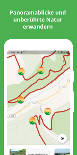
Impressive beech woods, cultural and historical attractions, the romantic Beketal, the highest point of Paderborn and again fantastic views are the characteristic features of the Paderborn Alta Via. The over 21 km long...
Impressive beech woods, cultural and historical attractions, the romantic Beketal, the highest point of Paderborn and again fantastic views are the characteristic features of the Paderborn Alta Via. The over 21 km long panoramic tour runs on both sides of Beketals on pleasant to walking forest trails.
A cross connection allows a 14-kilometer North and a 10 kilometer south courses.
As a starting point, has the "mission house" at the center of Neuenbeken. Gently but steadily, the trail climbs to first. Here, great wide views of Bad Lippspringe, the Senne and the Teutoburg Forest Open. Surprising it comes down to Beketal. After passing through a nearly 100 meter long railway underpass to reach the Dunetal which is spanned by the little viaduct - especially for car Visitors arriving - and also is a recommended starting point for the hike.
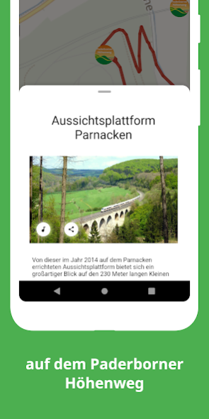
Around 150 meters of altitude are now overcome by the highest point of Paderborn. Passing the book with the two legs and the plague cemetery to do it - again and again with beautiful views - the former glassworks Uhden and the Mausoleum of the glassmaker family before is reached again after a short descent the starting point Mission House.
Since September 2014, the Paderborn trail may adorn the title "Walking in Germany Qualitätsweg". He thus joins in the 100 good quality hiking trails in Germany.
For more information: www.paderborner-hoehenweg.de
The route "Paderborner Trail" is part of the GPS Adventure Park Teutoburger Wald / Eggegebirge, which was once awarded "Education for Sustainable Development" by UNESCO as an official project of the UN Decade already three.
sawah® is also available for free for another adventure trails in the Nature Park.
Discover and experience the natural and cultural landscape in East Westphalia-Lippe in an innovative way - simple and mobile.
Please note: The continuous use of GPS running in the background can dramatically decrease battery life.
Note: When you first start the application approximately 25 MB of video and sound data are downloaded. It is recommended to load these data via a wireless connection.
Previous Versions
Here you can find the changelog of Paderborner Höhenweg since it was posted on our website on 2023-03-05 07:07:49.
The latest version is 5.1.2 and it was updated on 2024-04-22 16:17:08. See below the changes in each version.
Paderborner Höhenweg version 5.1.2
Updated At: 2019-11-21
Changes: - neues Design
- aktuelle Streckenführung
- Dark Mode
- manuelle Inhaltsaktualisierung
- Info zur Inhalts-Downloadgröße
- Download-Fortschrittsanzeige
Disclaimer
Official Google Play Link
We do not host Paderborner Höhenweg on our servers. We did not scan it for viruses, adware, spyware or other type of malware. This app is hosted by Google and passed their terms and conditions to be listed there. We recommend caution when installing it.
The Google Play link for Paderborner Höhenweg is provided to you by apps112.com without any warranties, representations or guarantees of any kind, so access it at your own risk.
If you have questions regarding this particular app contact the publisher directly. For questions about the functionalities of apps112.com contact us.